
Now Reading: Mapplic WordPress Plugin Review: Top Interactive Map Tool
-
01
Mapplic WordPress Plugin Review: Top Interactive Map Tool
Mapplic WordPress Plugin is the perfect solution for anyone looking to transform a basic image or floor plan into a fully interactive map without writing a single line of code.
If you’ve ever managed a mall, hospital, event venue, or real estate project, you know how hard it is to guide visitors using static images. People zoom, scroll, and still end up confused. What if your map could actually do something like highlight clickable points, allow zooming, and switch between floors?
That’s exactly what Mapplic helps you achieve. Let’s explore how it works, what it offers, and whether it’s the right fit for your next project.
Table of Contents
What Is the Mapplic WordPress Plugin?
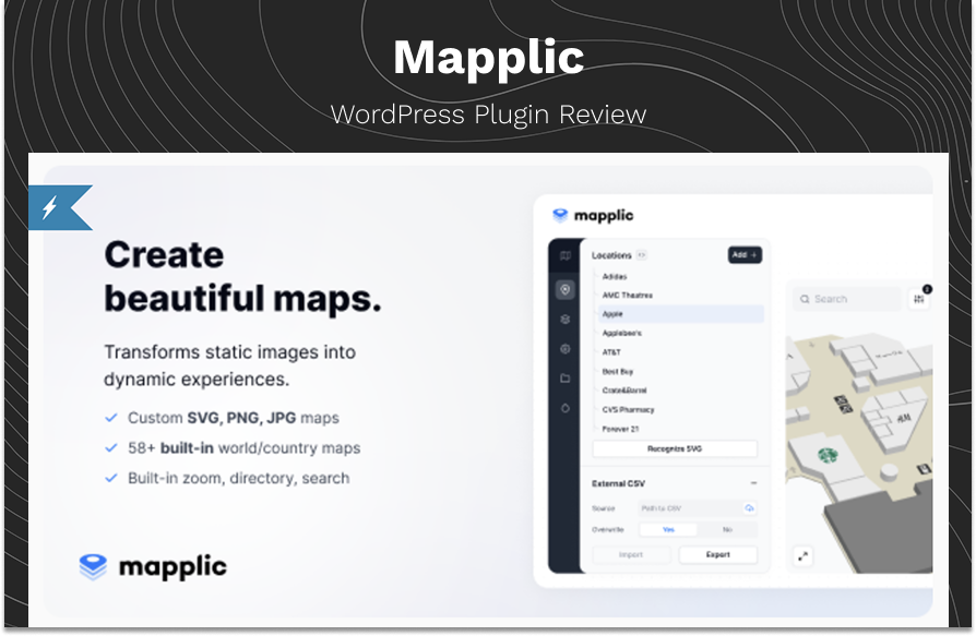
Imagine being able to take a simple image or map and turn it into something interactive, clickable, and useful. That’s exactly what the Mapplic WordPress Plugin does. It’s a tool designed to help you create custom interactive maps without breaking a sweat. Whether you’re working with an SVG, JPG, or PNG file, this plugin makes it super easy to transform static maps into dynamic experiences.
The Problem: Static Maps Aren’t Enough Anymore
Imagine you’re managing an event with dozens of booths, or a hospital with multiple departments spread across floors. You upload a basic JPG of your layout to your website. But what happens next?
Visitors squint, zoom in awkwardly, and still get lost. That’s not just frustrating it can cost you foot traffic, customer trust, or event satisfaction.
Static maps don’t solve the user experience problem. People need interactive navigation, clear, clickable paths that respond in real-time. This is especially true for mobile visitors and touchscreen users.
The Solution
The Mapplic WordPress Plugin bridges the gap between beautiful design and functional navigation. It turns your regular image or vector file, be it a PNG, JPG, or SVG into an interactive tool that users can zoom, search, and explore easily.
Key Features
1. Upload Any Custom Map You Want
Let’s say you have a custom floor plan of your building in JPG format. Simply upload it, and Mapplic lets you turn it into an interactive interface. No need to rely on Google Maps when your space is indoors or private.
Whether it’s a school layout, a campus map, or a trade show floor, Mapplic gives you full control over the visuals.
2. Add Clickable Locations with Descriptions
Imagine managing a large hospital. You want users to tap on “Pediatrics” or “Radiology” and get more info. With Mapplic, you just click the area on your map and assign it a name, link, or description.
“Adding click-points was incredibly intuitive. I created hotspots for 40+ booths at a local expo in under two hours.” — Jordan P., Event Coordinator
3. Multi-Level Support for Complex Structures
Got multiple floors? Just upload separate files for each level. Users can switch between them easily, like clicking “Ground Floor” or “First Floor” tabs.
This is ideal for:
- Shopping malls
- Office buildings
- Airports
- Museums
4. Zoom, Pan & Fullscreen Navigation
Have you ever struggled to pinch and zoom on a mobile site? Mapplic solves that. Visitors can pan across your map, zoom into sections, or even go fullscreen for better visibility especially useful on touchscreen kiosks.
5. Filterable Directory Sidebar
Let’s say you’re running a resort. Guests want to find restaurants, pools, or activity areas. With Mapplic’s built-in directory, users can filter and find exactly what they’re looking for without scanning the whole map.
6. CSV Import/Export to Save Time
Managing dozens of locations? Don’t input them one by one. Use a spreadsheet (CSV) to upload all your map data in bulk. You can even link it to a live CSV so updates happen automatically.
7. Simple Admin Panel with Live Preview
Even if you’re not tech-savvy, the admin interface is built for ease. Upload your map, add locations, preview changes, and hit publish. No coding, no confusion.
Real User Reviews
What do real users have to say about the Mapplic WordPress Plugin? Here’s a closer look at how people across different industries are benefiting from it — straight from their experiences:
tkemory,
“University WebmasterExcellent plugin, easy to use and excellent support. I’ve worked with multiple WordPress tools over the years, but Mapplic stands out for its professional layout and clean integration. I was able to set up an interactive campus map in under an hour. It made a great first impression on our site visitors.”
CitizenApollo
“Not only is the map excellent and friendly for those starting to code, but the author is very helpful. I had a minor issue with configuring layers for a multi-floor building and reached out for help. The support response was quick and clear, and they even guided me step-by-step. Can fully recommend this product.”
Freebeachbar
“Great work! The plugin is already fantastic, but I’d love to see a future update that allows area highlighting—something like drawing a polygon instead of just placing a pin. That would really take it to the next level. For now, it’s still the best tool I’ve found for visual interactivity.”
Built-In Maps Ready to Go
If you don’t have a custom image, Mapplic offers built-in maps for:
- World regions (Asia, Europe, Africa, etc.)
- Individual countries (USA, UK, India, Canada, etc.)
- Special areas like continents and subregions
This means you can start creating a map within minutes, even if you don’t have graphic assets on hand.
Compatibility Across Platforms
Mapplic works across all major website builders and CMS platforms:
- WordPress
- Shopify
- Webflow
- Wix
- Squarespace
- Framer
- HubSpot
Whether you’re a blogger or a full-scale marketing team, it fits seamlessly into your workflow.
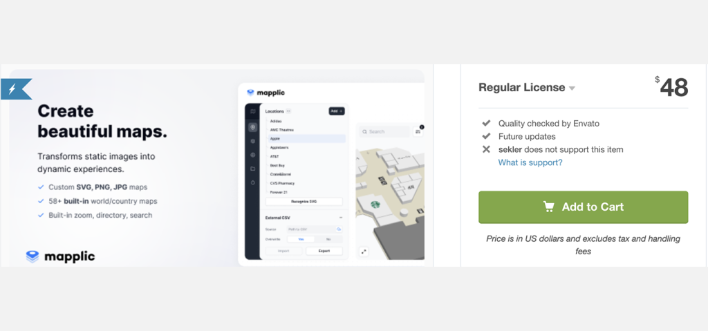
Pricing
You can find the Mapplic Plugin on CodeCanyon for $48 with a regular license. This price covers future updates and six months of support from the developer. For extended support, you can pay an additional fee, which is handy if you need long term help.
Pros & Cons
Pros
- Easy to set up and beginner-friendly
- Works with any custom map (JPG, PNG, SVG)
- Multi-floor support with floor switching
- Includes responsive directory, zoom, and fullscreen options
- Built-in maps save time and effort
Cons
- Not designed for street-level navigation
- No built-in polygon area highlighting (yet)
- Limited drawing tools without extra customization
- Custom styling may need light CSS tweaks
Constantly Improving with Modern Tech
As of Version 8, Mapplic was rewritten entirely in React, making it faster, smoother, and easier to manage. Regular updates now include:
- Wayfinding (shortest path finder)
- Code editor for advanced customization
- Responsive design for all devices
- Translations for global users
Final Thoughts
If you’re tired of flat, non-functional images on your site and need a visual tool that enhances usability, the Mapplic WordPress Plugin is one of the most user-friendly, customizable options available today.
It’s designed for people who want functionality without complexity and it does the job well.
Note: You can read more about similar products and explore all other software related reviews available on the Vidmate.
Previous Post
Next Post


Recent Comments


Advertisement

-
 01Ultimate Addons Review: Best Features & Benefits
 -
 02Crafto Template Review: Best Multipurpose HTML5 Features
 -
 03Koble Email Template Review: Best Mailchimp Templates
 -
 04Ella Shopify Template Review for eCommerce Success
 -
 05Uncode WordPress Theme Review: Best Choice for WooCommerce
 -
 06Story Mag Blogger Theme Review: Best For News Magazine
 -
 07eClassify Flutter App Review: Best Buy & Sell Marketplace